Aran Islands
Aran Islands consists of 3 remote and starkly beautiful islands - Innis Mor ("Big" Island), Innis Meain ("Middle" Island), and Innis Oirr ("Rear" Island), covering a total of 18 square miles and a total population of just1200. We are off to Innis Mor (Innishmore) which is the largest and the farthest and has a population of 800 and receives almost 2000 visitors daily during peak summer months. Most of the visitors are day trippers, but we plan to stay overnight. Most of the people on the islands speak Irish/Gaelic and English.
A large ferry takes visitors to these islands. It's an hour long ride. This was a much more pleasant ride than the boat we took to Skellig Michael.
The island is explored on bike, typically. Bikes are available for rent at 10 Euros for the day. They also have pony and trap or minivans that will take you around the island. Since it was a nice day, we decided to explore the island on bikes and rented 4 bikes.
There are almost no trees on the island, except near the pier where we landed. All the 3 islands have craggy vertical cliffs and windswept rocky fields with rock walls and very little topsoil. Tourism boosts the islands economy these days.
Alex had a beer with lunch at a local cafe. Great food with locally grown ingredients.
The main attraction on Innishmore is the Dun Aonghasa World Heritage site which is a 2000 year old Bronze/Iron Age stone fort protecting the island from Norman invaders. This fort sits on the edge of a cliff 200-300 feet over the wild Atlantic ocean and offers dramatic views. The first of the 4 semi circular walls are thought to be built around 1110 BC and then re-fortifed around 700-800 AD.
Parts of this fort is thought to have collapsed into the sea over the years, resulting in the semi-circular shape of the fort. You have to be careful at the edges not to get blown over with sudden gusts of wind or the edge breaking off into the sea below. Its a 1 km walk uphill over irregular stones to get to the fort on the cliff. Below is an ariel image of this prehistoric fort from google:
Welcoming the wind and the sea !
Alex tried taking a quick nap, but the 'bed' was too hard !
The kids enjoyed the view and the quiteness ! The crowds were gone by this time (3:30 pm)
The shoreline is beautiful and craggy !
We could see dark clouds moving in and a slight drizzle started. We quickly walked back down.
By now, you would have noticed that the landscape is very different here. This kind of landscape is called the Burren ("rocky place") and gives one the feeling of walking on the moon. There are massive boulders and flat rocks with cuts on them and are made of limestone. Limetone is a sedimentary rock, composed mainly of skeletal fragments of marine organisms such as coral, molluscs etc and is composed of calcium carbonate variants. The solubility of limestones in water and weak acid solutions leads to what is known as "Karst" landscape, in which water erodes the limestone over million of years. You will see that in the pictures below.
This area looked desolate and stark !
Couldn't resist getting a few star jumps in on the Burren rocks!!
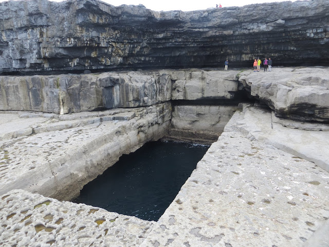
Next big attraction is the Wormhole (also known as The Serpent's Lair). A naturally formed 40 ft x 100 ft rectangular hole that is 60 ft deep. You have to hike 15-20 min over a boulder rock field to get there.
Cliff diving competitions are held in this location. You can watch a Youtube video of the Red Bulls diving championship here: Wormhole Cliff Diving Championships. It seems quite scary !
It was a bit odd that an almost perfect rectangular hole was formed naturally...but the locals were emphatic about it. It has to do with the properties of limestone. Limestone breaks at right angles and the hole was caused when the hidden cave under it collapsed into the sea.
The wormhole is massive in size and you need to get up close to realize it ! You can kind of see Alex and the kids against the cliffs and I am standing on the opposite side of the wormhole closer to the ocean. During high tide, the ocean waves will splash out of the wormhole and also into the wormhole.
Fooling around under gigantic rock caves beneath the cliffs !
The pools of water collected on the rocks had different colors.
You can see the Karst landscape on the rocks next to the wormhole.
Walking back to the bikes. The moonscape-like landscape is striking !
Satto injured his leg hiking over the rocks. Some kind Irish folks gave him bandages.
A seal colony! We were able to see about 10 seals lazing around at the shore basking in the evening sun.
We returned the bikes and headed out to dinner. Tomorrow, we will be sad to leave this beautiful island. The sense of remoteness was much more after all the day crowds left and we seemed to have the whole island to ourselves !!


Comments
Post a Comment